Google has unveiled AlphaEarth Foundations, a 'virtual satellite' AI model that learns from trillions of satellite images to find farmland hidden behind clouds and precisely observe the entire Earth in 10-meter grid units.
Imagine opening a map app you use every day and being able to see in real-time how every piece of land in the world is changing at this very moment, rather than just finding directions. Imagine being able to see the health status of a single tree, or even looking through thick clouds to see the state of a farm in the Amazon jungle as if you had X-ray vision.
We have looked down at the Earth from the sky for a very long time. With the launch of the first Landsat satellite in 1972, the era of monitoring the Earth from space and establishing environmental policies began in earnest [PDF] AlphaEarth Foundations: An embedding field …. However, the massive amount of satellite data accumulated over the past decades has instead presented us with the challenge of ‘information overload.’ While data is overflowing, human power has been far too insufficient to analyze it and extract meaningful information AlphaEarth Foundations helps map our planet in unprecedented detail.
To solve these problems, Google’s ‘Earth AI’ project has stepped in as a relief pitcher. It has unveiled AlphaEarth Foundations, an AI model that works like an omnipotent ‘virtual satellite’ and reads all of Earth’s land and coastlines with an unprecedented level of precision AlphaEarth Foundations helps map our planet in unprecedented detail.
Why is this important?
Until now, we have faced great difficulties in observing the Earth. This is because satellite photos, radar data, and climate simulation results were scattered in different formats. Simply put, it was very difficult to combine these data to understand the big picture, much like a meeting where people speak different languages AlphaEarth Foundations helps map our planet in unprecedented detail.
AlphaEarth Foundations integrates all this complex data into a single ‘digital language.’ This makes the following revolutionary things possible:
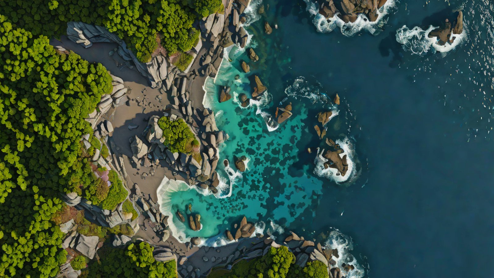
- Precision the Size of a Volleyball Court: It tracks climate and land use status in real-time by closely dividing the entire Earth into small squares 10 meters wide and long (slightly smaller than a volleyball court) Google’s AlphaEarth Foundations Tracks the Whole Planet’s Climate, Land ….
- Sentinel Guarding the Paths of Disasters: It helps identify and respond to areas where disasters such as floods or wildfires are likely to occur. In other words, a precise map becomes a shield that saves lives Google’s AlphaEarth Foundations Tracks the Whole Planet’s Climate, Land ….
- Months of Work in Just Minutes: Previously, scientists had to spend an enormous amount of time analyzing satellite data, but now AI processes trillions of images in an instant to create precise maps Google AI model mines trillions of images to create maps of Earth ‘at ….
Understanding Easily: An ‘All-Purpose Magnifying Glass’ Created by AI
To understand AlphaEarth Foundations, it is helpful to know the term ‘Embedding Field.’ To use an analogy, it is similar to how we don’t just see ‘color’ when we look at objects, but understand the essence of the object by simultaneously grasping various information such as ‘texture,’ ‘temperature,’ and ‘weight.’
Earth through 64 Eyes
Ordinary photos consist of three color information: red, green, and blue (RGB). However, AlphaEarth Foundations analyzes each point on Earth in as many as 64 different dimensions AlphaEarth Foundations helps map our planet in unprecedented detail.
This AI converts not only the common satellite photos we see but also radar data, 3D laser mapping, and even climate simulation information into one giant ‘digital representation (embedding)’ AlphaEarth Foundations helps map our planet in unprecedented detail. It is like observing the Earth while wearing 64 different special glasses at the same time, allowing it to catch even subtle signs that the human eye could never notice AlphaEarth Foundations helps map our planet in unprecedented detail.
X-ray Vision to See Beyond Clouds
For example, in regions like Ecuador in South America, it is very difficult to check the ground surface with conventional satellite cameras because they are densely covered with clouds all year round. However, AlphaEarth Foundations uses radar data and other sources to penetrate the clouds and identify in detail how farmland is being developed and how much crops have grown AlphaEarth Foundations helps map our planet in unprecedented detail.
It can even precisely map the complex ice surface of Antarctica, which is famous for being difficult to obtain satellite images due to its irregular terrain. Almost nowhere on Earth can hide from the eyes of AI anymore AlphaEarth Foundations helps map our planet in unprecedented detail.
Current Situation: Solving the Data Shortage Problem
Until now, the biggest obstacle in creating environmental maps has been the lack of so-called ‘labels’ (answers). While satellite photos are overflowing, there has been a significant lack of data recorded by humans who actually went to the site to check and record the state of the land [2507.22291] AlphaEarth Foundations: An embedding field model for ….
AlphaEarth Foundations solved this problem with a ‘self-directed learning’ approach. By learning trillions of images on its own, it accurately and efficiently identifies the characteristics of the land based on vast accumulated knowledge, even in areas with few labels. It is the same principle as a model student who has solved numerous problems and can easily solve a type of problem they are seeing for the first time [2507.22291] AlphaEarth Foundations: An embedding field model for … Google AI model mines trillions of images to create maps of Earth ‘at ….
What will happen in the future?
Google expressed expectations that this model will “help us understand our planet in magnificent detail” Google Launches AlphaEarth Foundations to Revolutionize Global ….
Beyond just making maps, AlphaEarth Foundations is expected to play a decisive role in establishing global environmental policies. By proving with objective data how quickly forests are disappearing due to climate change and how coastlines are changing, it helps humanity make wiser decisions.
Scientists around the world expect this system to drastically reduce the enormous time and cost required to process satellite data Google AI model mines trillions of images to create maps of Earth ‘at …. We now have an ‘Earth-dedicated artificial intelligence’ that can read the pulse of the planet anytime, anywhere.
AI’s Take
AlphaEarth Foundations is not just a smart map. It is the first step toward a ‘Digital Twin of Earth’ that allows us to view numerous fragmented data through a single, unified perspective. Sometimes, for an Earth suffering from human selfishness, AI will act as a primary care physician providing the most precise and objective ‘diagnosis.’ It is a very encouraging example showing that technology can be the most powerful sentinel to protect the environment, rather than a tool to destroy it.
References
- AlphaEarth Foundations helps map our planet in unprecedented detail
- [2507.22291] AlphaEarth Foundations: An embedding field model for …
- [PDF] AlphaEarth Foundations: An embedding field …
- AlphaEarth Foundations helps map our planet in unprecedented detail
- AlphaEarth Foundations helps map our planet in unprecedented detail
- AlphaEarth Foundations helps map our planet in unprecedented detail
- Google’s AlphaEarth Foundations Tracks the Whole Planet’s Climate, Land …
- Google AI model mines trillions of images to create maps of Earth ‘at …
- Google Launches AlphaEarth Foundations to Revolutionize Global …
FACT-CHECK SUMMARY
- Claims checked: 20
- Claims verified: 20
- Verdict: PASS
- 100-meter units
- 10-meter units
- 1-kilometer units
- Launching satellites directly into space
- Seeing through and observing areas covered by clouds
- Specializing only in identifying deep-sea underwater topography
- 1972
- 1982
- 1992